What Are Tropical Cyclones?
Tropical cyclones are intense circular storms that form over warm ocean waters. They bring very strong winds, heavy rain, thunder, and rough seas, and can cause flooding, storm surges, and damage to buildings and vegetation.
Each cyclone has a central calm area called the eye, surrounded by spiral bands of cloud, rain, and powerful winds. The winds can reach speeds well above 100 kilometers per hour, and rainfall can last for several hours or days.
While the Maldives rarely experiences direct cyclone landfalls, severe weather from nearby systems — such as strong winds, heavy rain, and rough seas — can still have serious impacts on island communities, fishing vessels, and resorts.
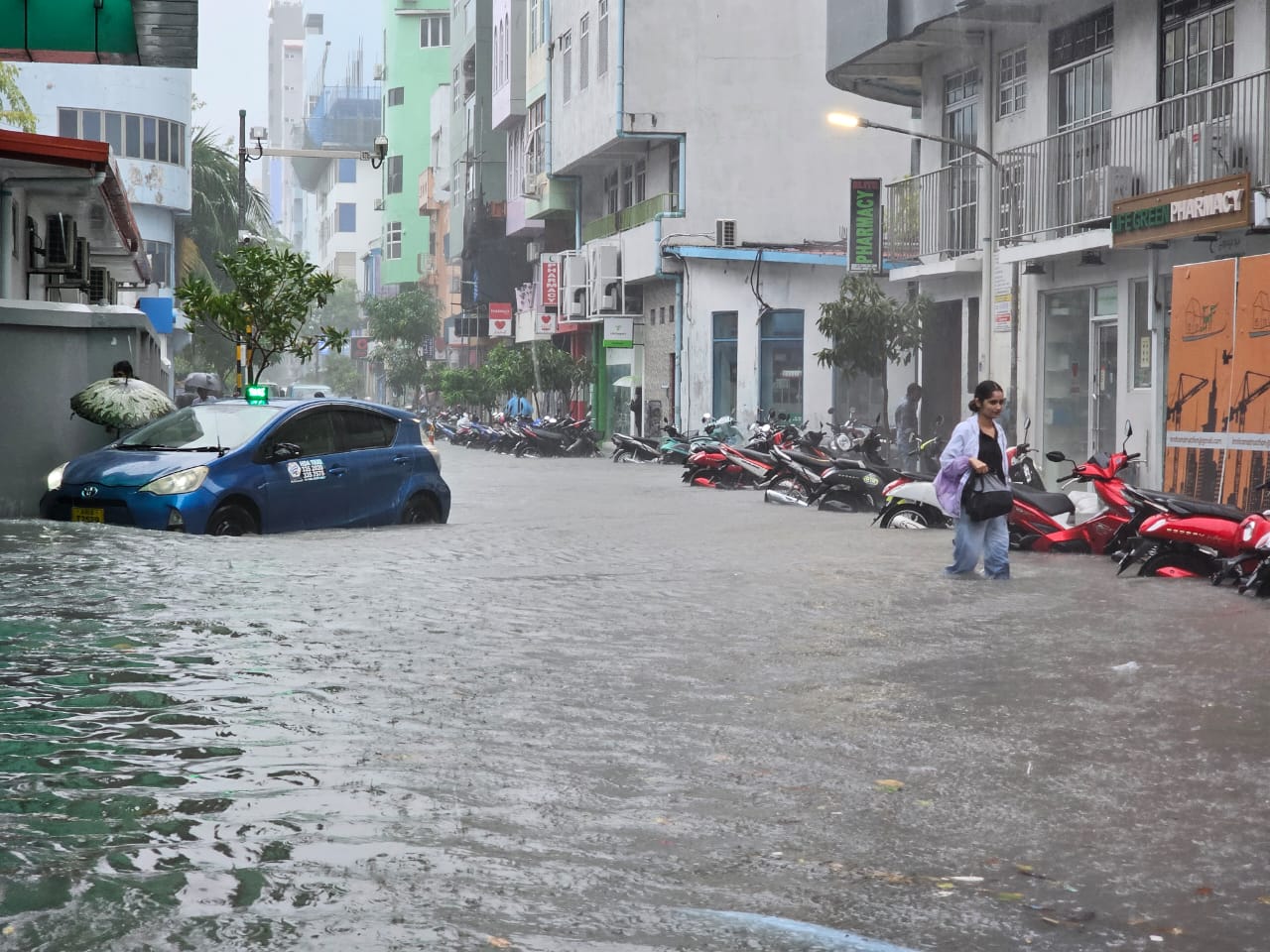
Residents wade through flooded streets in Malé City following heavy rainfall and surface water flooding. Photo: NDMA
How Cyclones Affect the Maldives
Tropical cyclones that influence the Maldives usually form over the Arabian Sea or the Bay of Bengal. Most of these systems move across the open Indian Ocean, passing north or northeast of the country, but their outer wind and rain bands can still affect local islands.
Historically, only a few cyclones have passed close to the Maldives, with most impacts coming from strong winds, heavy rain, and rough seas generated by nearby systems. These storms can cause coastal flooding, damage to roofs, and interruptions to electricity and communication.
Scientists and forecasters identify two key regions that influence cyclone activity near the Maldives:
Arabian Sea Region (West of Maldives): The main source of cyclones that affect the northern atolls, particularly Haa Alifu and Haa Dhaalu. These storms often develop during the southwest monsoon season (May–November).
Bay of Bengal Region (East of Maldives): Occasionally influences the central and southern atolls through strong winds and heavy rainfall. Though direct cyclone impact is rare, storm surges and rough seas can reach the eastern coastlines.
Because the Maldives lies close to the equator, full cyclone formation directly over the islands is uncommon. However, associated weather hazards including intense rain, wind, and sea swells are frequent and can cause widespread disruption, especially to low-lying areas and coastal infrastructure.
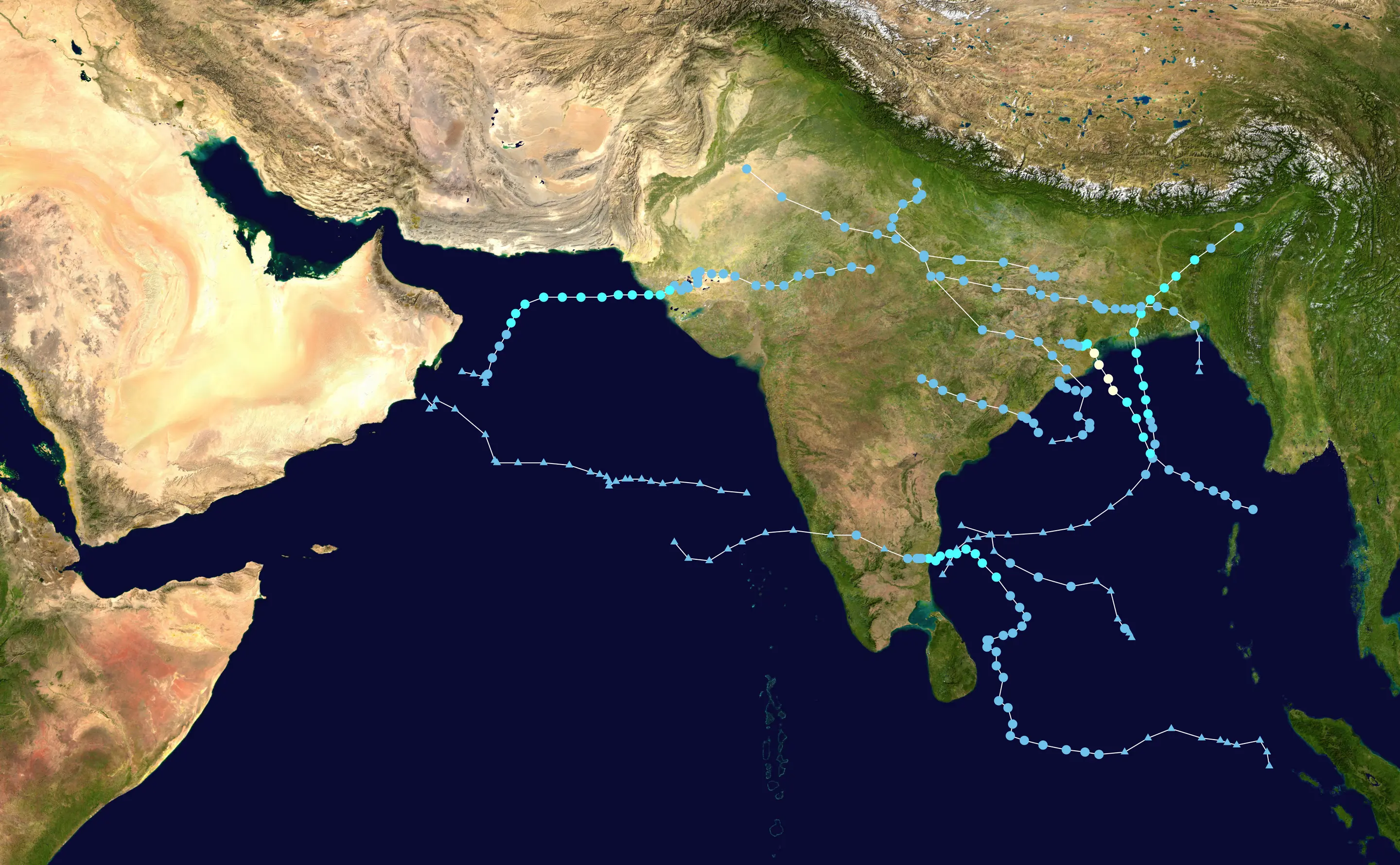
This map shows the tracks of all tropical cyclones in the 2024 North Indian Ocean cyclone season. The points show the location of each storm at 6-hour intervals. The colour represents the storm's maximum sustained wind speeds as classified in the Saffir-Simpson Hurricane Scale. Source: 2024 North Indian Ocean cyclone season - Wikipedia
Cyclone Risk Zones in the Maldives
Cyclone exposure in the Maldives varies across the country. Historical records show that the northern atolls are most at risk from tropical cyclones and strong winds generated in the Arabian Sea, while the central and southern atolls face lower risk, mostly from peripheral effects such as heavy rainfall, rough seas, and swells.
The map below illustrates the five hazard zones identified in national risk assessments, based on probable maximum cyclone wind speeds (measured in knots). These zones reflect how wind intensity and storm frequency decrease from north to south.
Zone 5 – Very High Risk (Atolls: Haa Alifu, Haa Dhaalu, Shaviyani)
Located closest to the main cyclone tracks in the Arabian Sea.
Most likely to experience high winds, heavy rainfall, and rough seas when tropical cyclones pass nearby.
Communities should prioritize roof reinforcements, secure mooring areas, and ensure emergency supplies before the cyclone season.
Zone 4 – High Risk (Atolls: Noonu, Lhaviyani, Raa, Baa)
Still within the cyclone influence zone but with slightly reduced intensity.
Wind damage and heavy rain can occur, particularly during strong pre-monsoon and post-monsoon systems.
Coastal protection and early warning systems are essential in these areas.
Zone 3 – Moderate Risk (Atolls: Kaafu, Alif Alif, Alif Dhaalu, Vaavu)
Occasionally affected by cyclonic winds and associated sea surges.
Impacts include flooding of low-lying areas, roof damage, and transportation disruptions.
Community-level preparedness, drainage maintenance, and secure shelters reduce risks.
Zone 2 – Low Risk (Atolls: Meemu, Faafu, Dhaalu, Thaa, Laamu(
Rarely affected by direct cyclone winds.
May experience heavy rainfall, rough seas, and swells during large regional systems.
Fishermen and sea travelers should monitor MET advisories closely during the monsoon months.
Zone 1 – Very Low Risk (Atolls: Gaafu Alifu, Gaafu Dhaalu, Gnaviyani, Seenu)
Least affected by cyclonic activity due to their southern equatorial position.
Local hazards are generally linked to monsoonal storms, squalls, and strong winds from passing systems.
Continued vigilance is needed for maritime safety and coastal flooding events.
Historical records show that the northern atolls are most vulnerable to cyclone winds, while central and southern atolls mainly experience strong winds and rough seas when systems pass nearby.
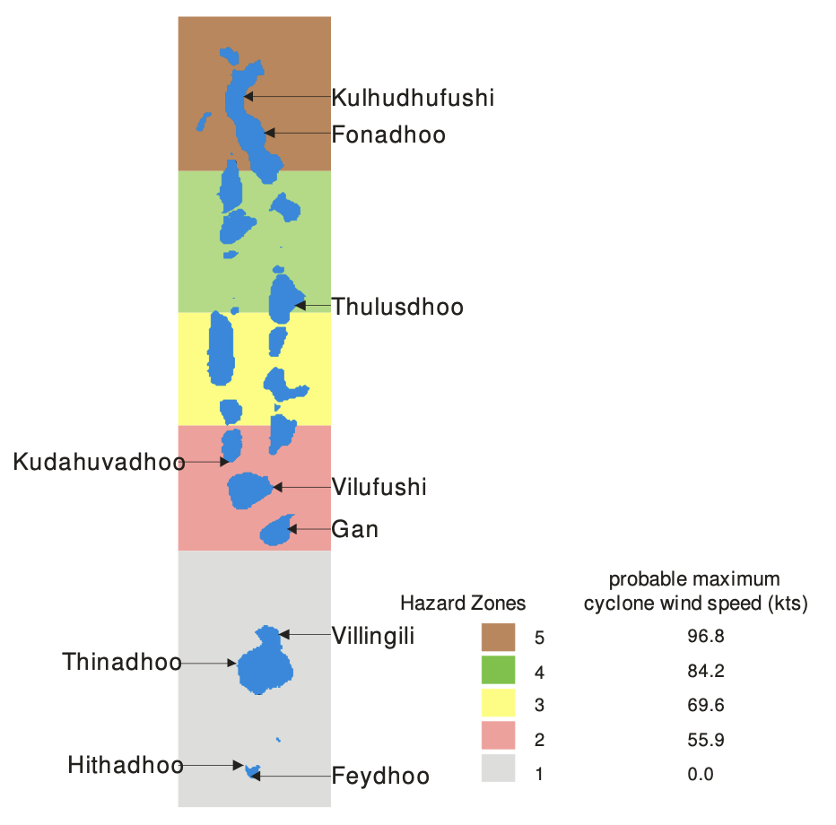
Cyclone hazard zones of the Maldives as defined by UNDP (2006).
Cyclone Alerts in the Maldives
The Maldives Meteorological Service (MMS) monitors developing weather systems and issues alerts in coordination with the National Disaster Management Authority (NDMA).
Alerts are color-coded so communities can understand the level of risk and act accordingly:
⚪ Alert White: Information
Cyclone formation or distant disturbance detected.
Stay alert and follow official updates.
🟡 Alert Yellow: Advisory
Potential for strong winds, rainfall, or rough seas within 24–48 hours.
Secure homes, boats, and loose outdoor items.
🟠 Alert Orange: Warning
Cyclone system approaching or nearby; severe weather expected.
Stay indoors, avoid travel, and prepare for emergency measures.
🔴 Alert Red: Severe Warning
Cyclone or destructive winds imminent or impacting the country.
Move to safe shelter if advised.
Stay in protected areas until the all-clear.
Natural Warning Signs
Even before alerts are announced, certain signs may indicate worsening weather:
Rapidly darkening skies and continuous thunder.
Strong, gusty winds increasing over time.
Rough and rising sea levels near the coastline.
Heavy and persistent rainfall.
When these occur, avoid outdoor activities and stay tuned to official weather information through radio, TV, or mobile alerts.
Staying Prepared Year-Round
Conduct community clean-ups and drainage maintenance.
Reinforce public buildings and schools as safe shelters.
Train local volunteers for emergency response.
Maintain updated emergency contact lists.
Keep communication devices charged during severe weather.
Cyclones may be rare, but early action and awareness ensure that communities stay resilient and safe.
Before a Cyclone: Get Ready
Preparation is the most effective protection. Every household, school, and workplace should take simple steps before the cyclone season and when warnings are issued.
Secure roofs, windows, and doors to prevent damage from strong winds.
Move boats and equipment to safe harbor or higher ground.
Check and clean drainage systems to reduce flooding risk.
Store emergency supplies: water, food, torch, batteries, first aid items, and important documents.
Know safe shelters in your island and how to reach them.
Stay informed through MET forecasts and NDMA advisories.
Local councils should identify safe buildings, check emergency shelters, and ensure communication with residents ahead of every cyclone season.
During a Cyclone: Stay Safe
Stay indoors and keep away from windows and glass doors.
Do not go outside even if the weather appears calm — it may only be the cyclone’s eye.
Use emergency lighting instead of candles to avoid fire hazards.
Disconnect electrical appliances if instructed.
Listen to official updates from NDMA or your island council before moving or evacuating.
If at a resort or guesthouse, follow staff instructions and remain in designated safe areas.
Remaining calm and following safety instructions helps prevent injuries during the storm.
After a Cyclone: Stay Safe
When the cyclone has passed:
Wait for official clearance before going outside.
Avoid damaged power lines, flooded areas, and debris.
Assist family and neighbors who may need help.
Clean and disinfect living areas to prevent health risks.
Inspect boats and roofs only when it is safe to do so.
Report damages to your island council or NDMA team for assistance.
Avoid the temptation to go sightseeing or take photos immediately after the event — conditions may still be unsafe.